


“Samarkand-2028” Heads to Orbit with an Uzbek AI Module
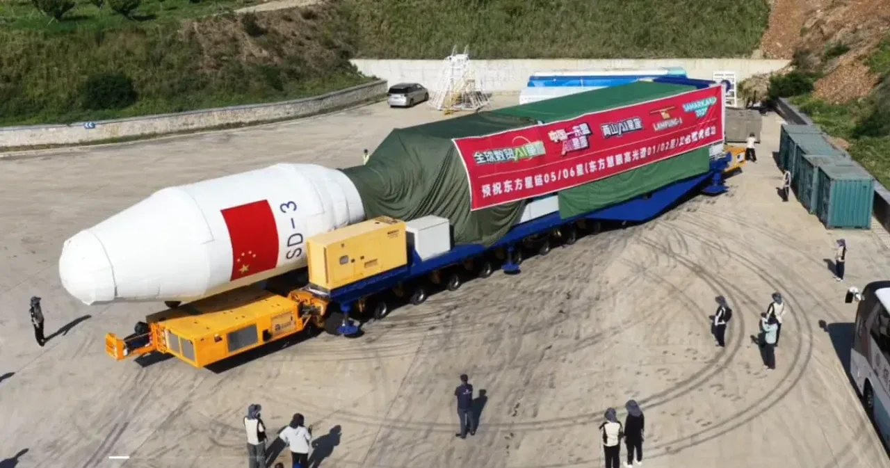
Uzbekistan is taking a new practical step in space technology. According to the information presented, the hyperspectral satellites “Samarkand-2028” and “Lampung-1” are scheduled to launch on August 5 from a sea launch platform near the coast of China’s Shandong Province.
The project’s most important aspect for Uzbekistan is not just the satellite’s name. Specialists from “Uzbekcosmos” took part in developing an AI module designed to analyze images directly in orbit. The agency described this as the first participation of Uzbek specialists in creating an AI module for a satellite.
Two satellites to launch from a sea platform
According to the plan, “Samarkand-2028” will be launched into space together with Indonesia’s “Lampung-1” satellite. The launch will be carried out by the Chinese company STAR.VISION which specializes in space computing technologies and AI solutions.
The “Lampung-1” project STAR.VISIONdeveloped it in cooperation with the operator of the Eastern Spaceport in Shandong and Indonesia’s Lampung Province. Its main tasks include monitoring agriculture, marine areas, the environment, and natural resources. The company also said that the project would use onboard AI and orbital computing technologies.
Since the launch has not yet taken place, the date and time may change because of technical checks, conditions at sea, or the weather. The final outcome will be known after the rocket launch and the deployment of the satellites into their designated orbits are officially confirmed.
How did “Samarkand-2028” come about?
The “Samarkand-2028” project is the result of a strategic memorandum signed in 2025 between the Uzbekcosmos agency and STAR.VISION The cooperation covers satellite technology development, joint projects, stronger scientific and technical integration, and the involvement of universities and technology companies.
The cooperation covers satellite technology development, joint projects, stronger scientific and technical integration, and the involvement of universities and technology companies.
Under the memorandum, STAR.VISION agreed to name one of its hyperspectral satellites “Samarkand-2028”. The parties also agreed to explore the possibility of creating maps of Uzbekistan’s cotton and wheat fields based on satellite data.
There is an important clarification here: it would not be correct to call “Samarkand-2028” a fully national satellite of Uzbekistan. The satellite is a STAR.VISION project, while Uzbekistan is participating by providing the name, helping develop the AI module, and using the data obtained.
Why “Samarkand-2028”?
The satellite’s name commemorates Samarkand’s hosting of the 2028 International Astronautical Congress.
Uzbekistan nominated Samarkand rather than its capital and competed against Mumbai, India, and Manama, Bahrain. The final presentations took place during the International Astronautical Congress held in Sydney in 2025.
The International Astronautical Federation confirmed that Samarkand had been selected to host the 79th International Astronautical Congress in 2028. The organization noted that the event brings together thousands of space agency leaders, scientists, engineers, companies, and young professionals every year.
In this sense, “Samarkand-2028” is not only a technical project but also a symbolic name representing Uzbekistan’s integration into the global space community.
What can a hyperspectral satellite see?
A conventional optical camera images Earth’s surface in red, green, and blue colors close to human vision. Multispectral satellites also capture additional invisible information across several broad spectral bands.
A hyperspectral sensor expands these capabilities further. It divides the light reflected from each area into many narrow spectral channels, identifying the distinctive “spectral signature” of a material or object.
For example, two plants that look equally green to the human eye may differ: one may be healthy, while the other may be suffering from a lack of water, minerals, or nutrients. Hyperspectral imaging can detect this difference before visible symptoms become obvious.
STAR.VISION says that this technology can be used to:
distinguish crop types and assess their condition;
monitor water quality and pollution;
detect changes in forests and ecosystems;
analyze the composition of soil and rock;
search for mineral resources;
study urban infrastructure and land cover
among other tasks.
What does AI in orbit provide?
Conventional Earth-observation satellites collect large volumes of raw imagery and attempt to transmit it to a ground receiving station. The data is then processed on servers and prepared for analysis.
The AI module developed for “Samarkand-2028” is designed to analyze some of the data directly onboard the satellite.
In practical terms, this could provide the following benefits:
Traditional process | With onboard AI |
|---|---|
All raw data is sent to Earth | Relevant data is filtered in orbit |
Analysis begins on the ground | Initial analysis is performed onboard |
Significant communications resources are required | The volume of transmitted data may be reduced |
It takes longer to obtain results | Important objects may be detected faster |
For example, AI could filter out cloud-covered or low-quality frames, identify specific crop fields, or initially screen areas with a high probability of environmental change.
However, the module’s exact algorithms, computing power, and complete list of orbital tasks have not yet been publicly disclosed. Its actual effectiveness will therefore be assessed through tests after launch.
What changes could agriculture see?
In Uzbekistan, one of the most promising applications of hyperspectral data is agriculture.
Satellite data could help to:
identify fields planted with cotton and wheat;
monitor crop development;
detect early signs of water shortage;
assess the effects of disease or pests;
plan irrigation and fertilization more precisely;
improve yield forecasts
and expand related capabilities.
However, satellite imagery cannot completely replace a farmer or agronomist. Reliable results require comparing space-based data with ground samples, meteorological indicators, and field observations.
A new tool for environmental and resource monitoring
Hyperspectral observation can also help study water bodies, forests, desertification, and changes in mining areas.
For example, the technology can distinguish certain changes in water composition, stress in vegetation, or differences in soil properties through spectral indicators. STAR.VISION has noted that hyperspectral data can be used for environmental monitoring, water-quality assessment, mineral exploration, and evaluating the consequences of natural disasters.
For Uzbekistan, this could create an additional source of data for areas such as the Aral Sea region, water scarcity, land degradation, and the condition of forests and pastures.
Will it start working immediately after launch?
The mission’s most important phase does not end when the rocket places the satellite into orbit. On the contrary, the satellite commissioning process begins only afterward.
Specialists typically:
establish a stable connection with the satellite;
check the solar panels and main systems;
determine the orbital parameters;
calibrate the hyperspectral camera;
test the AI module;
compare initial images with ground-based data.
Only then does the phase of regular data collection and practical use begin. Therefore, even if the launch is successful, the results of using “Samarkand-2028” will not be visible immediately, but only after technical tests.
What is the main result for Uzbekistan?
It is not enough to view “Samarkand-2028” merely as a name being sent into space. The project’s strategic importance lies in involving Uzbek specialists in creating technologies that operate onboard the satellite.
This experience could lay the foundation for:
developing software solutions for national satellites;
processing space data under local conditions;
involving universities and engineers in practical projects;
building national expertise in remote sensing of Earth;
strengthening Uzbekistan’s standing ahead of the 2028 International Astronautical Congress
and related goals.
If the planned launch on August 5 is successful, the name “Samarkand-2028” will appear in orbit. But the mission’s real value will become clear later—when the onboard Uzbek AI module begins operating and the data collected starts helping solve practical problems in the country.
In your opinion, which area in Uzbekistan should use satellite data first—agriculture, environmental protection, or water monitoring? Leave your thoughts in the comments and share the article with your contacts on Telegram or other social networks!



Comments 0
…