


Yandex Maps launches revolutionary navigation in three major cities of Uzbekistan
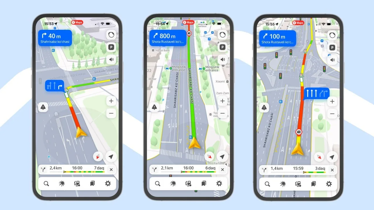
The stressful situation familiar to every driver is coming to an end: you are driving through an unfamiliar street or a complex multi-level interchange, with several directions ahead, and you realize which lane to turn or exit from only a few seconds before. At such moments, sudden braking, risky lane changes based on guesswork, or traffic violations often caused numerous road accidents and traffic jams. Now, a new digital feature that fundamentally eases the lives of millions of Uzbek drivers has been introduced: the Yandex Maps app has officially launched highly detailed maps of the roads in Tashkent, Andijan, and Namangan.
This update shows not only the general route, but also specific traffic lanes, markings, exits, and safety islands with exceptional precision. As a result, the service clearly indicates the recommended movement trajectory well in advance, allowing the driver to calmly move into the necessary lane beforehand. To launch this complex feature, the Yandex team fully digitized a total of 2,760 kilometers of road infrastructure across the three major cities.
So, how does detailed navigation practically help drivers, to what extent are fines and the risk of accidents reduced, and in which regions is the system operating at full capacity?
"Precise lanes, 2,760 km of digitization, and calm turns": 5 key points of the update
Key facts and details about the new navigation feature by Yandex Maps in Uzbekistan:
Knowing which lane to take in advance: The navigator shows the driver exactly which lane to take for the necessary turn or exit at complex interchanges;
An end to sharp and dangerous maneuvers: Confusion and emergency situations like "where was I supposed to turn?" at the last second are prevented;
Every road line and safety zone on the map: In addition to traffic lanes, dividing lines, overpass exits, and safety islands are visually reflected in the app;
A massive effort of 2,760 kilometers: To introduce this system, specialists digitized 2,760 km of road infrastructure down to the smallest details across the three cities;
Coverage areas: In Tashkent, the new map works fully on all roads, while in Andijan and Namangan, it covers central areas and major highways.
Yandex Maps navigation: Comparison between the traditional map and the new detailed system
Analysis of new parameters for road safety and navigation convenience:
Indicators and features | Previous traditional navigation | New detailed Yandex Maps system |
Route display | Only general road line and turn arrow | Every traffic lane, dividing line, and area |
Lane selection timing | Shown at the last minute, right next to the turn | Movement trajectory recommended well in advance |
Maneuver safety | High risk of sudden left/right cuts at high speed | Calm, smooth transition into a pre-designated lane |
Risk of violations and fines | High probability of crossing lines or turning from the wrong lane | Strict and error-free compliance with Traffic Rules (TR) |
Tashkent city coverage | Standard street map | 100% of the capital's streets are digitized |
Coverage in Andijan and Namangan | Coordinates of main roads | Central areas and important arterial roads |
Total digitized distance | Main network only | A full road network of exactly 2,760 kilometers across three cities |
Auto expertise and urban planning analysis: Why does this feature sharply reduce traffic jams and accidents?
Conclusions of road safety experts and analysts:
Elimination of the "sudden stop" effect: When a driver realizes too late on multi-lane roads that their lane is wrong, they try to suddenly stop or forcefully barge into the traffic flow of the adjacent lane; the detailed map puts an end to such disorder and ensures smooth traffic flow;
Protection from traffic cameras and fines: Recently, the number of automated cameras for crossing road lines and violating lane discipline has increased; the new system shows the driver the permitted lane in advance, saving them from accidental, unnecessary fines;
Infrastructure in regions outside the capital: The project not being limited to Tashkent, but extending to Andijan and Namangan—the two largest and most densely populated centers of the Fergana Valley—is of vital importance in developing regional transport culture;
Psychological relief and convenience: A driver can fully plan their next move with a single glance at the map without getting distracted on the road, which reduces mental stress and fatigue.
The digitization of 2,760 kilometers of roads has been a major step toward creating a modern "smart transport" and safe road ecosystem in the cities of Uzbekistan.
How much do you think this new feature of Yandex Maps, which indicates the correct lane in advance, helps reduce traffic jams and violations on the roads? Do you often encounter situations where you struggle not knowing which lane to take on unfamiliar streets? Leave your personal thoughts and experiences in the comments and share this extremely useful news, vital for all your driver friends!



Comments 0
…