


Rare climate phenomenon in the Atlantic Ocean: Unexpected changes in global weather
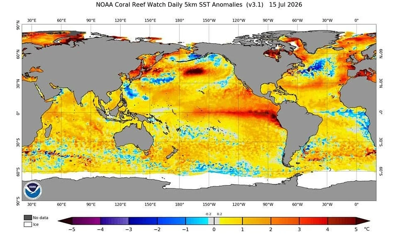
While a powerful El-Niño event is forming in the Pacific Ocean, meteorologists are recording a rare climate anomaly in the tropical Atlantic — the Atlantic Niña. This phenomenon, associated with an unusual drop in water temperature in the eastern equatorial part of the ocean, has been observed only 5 times in the last 40 years and is expected to have a significant impact on the global weather system. This is reported by Ixbt.com reports .
The Atlantic Niña should not be confused with the well-known La-Niña in the Pacific. Although both phenomena are related to the cooling of water, they occur in different oceans and within different climate cycles. According to the US National Oceanic and Atmospheric Administration (NOAA), if the surface temperature in the Atlantic remains at least 0.5 degrees below normal for two consecutive seasons, it will be officially confirmed as the sixth rarest case in the current decade.
Interaction of two different anomalies
Currently, NOAA maps show two opposing scenes simultaneously: a warm El-Niño current near the coast of South America and a cold Atlantic Niña region forming off the southeastern coast of Africa. Andrej Flis, an expert at the Severe Weather Europe portal, notes that although these two systems are different in nature, they have a similar effect on atmospheric processes.Specifically, both systems reduce the likelihood of strong hurricanes forming in the Atlantic. While El-Niño increases vertical wind shear, preventing thunderstorm systems from developing into major cyclones, the Atlantic Niña limits the rise of heat and moisture into the atmosphere due to the cold ocean water. This complicates the convection process and prevents storms from intensifying.
Decline in hurricane season
According to statistics, the number of tropical cyclones during the Atlantic Niña period is nearly 50 percent lower than during the reverse warm phase — the Atlantic Niño. The 2026 hurricane season is developing much weaker than expected so far. For example, while two named storms usually form by mid-July, only tropical storm "Arthur" has been recorded this year.At the moment, the US National Hurricane Center (NHC) is monitoring two areas where new cyclones could form, but the probability of their intensification is estimated to be very low (10-20 percent). In the Pacific, the situation is completely different: warm waters influenced by El-Niño are creating conditions for active storm formation; in particular, tropical storm "Elida" is currently moving westward away from land.
Although the combination of El-Niño and the Atlantic Niña reduces the risk of major hurricanes for the US coast, experts advise against complacency. This is because the peak of climate activity in the ocean usually occurs in August, and the situation can change at any time. For continental regions like Uzbekistan, such ocean anomalies do not pose a direct threat, but they alter the movement of global air masses and affect long-term precipitation and temperature forecasts.


Comments 0
…